World Map Posters

World Map Poster
During the earlier years of our homeschooling, we had a world map poster on our dining room / school table because there was no room on the walls. To protect the map, I made a transparent tablecloth from some thick plastic, sewing elastic around the edges so it easily stayed on the table. We would refer to this world map regularly while studying literature, history, Bible, current affairs and more. It stayed there on the table for many years until the plastic cover deteriorated.
Whether you put your world map poster on a table or on a wall, it will have great educational value partly because it is so easily accessible. Atlases are great, but it's more effort to first find the book then find the page with the map you want to investigate. A world map poster is always in view and information will be absorbed almost without trying.
This page not only includes world maps suitable for kids but also posters suitable to be used in offices and other work places or as stylish talking points in your home.
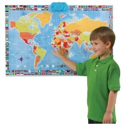
Pictured above: Zanzoon Map World - Interactive Talking World Map.
Maps of the World for Kids
Illustrated Map of the World for KidsBuy Now
This fun, educational, 27.5" x 39" map of the world shows geographical features such as country borders, country capitals, major cities, mountain ranges, lakes, and major rivers. It also includes more than 300 illustrations showing animals of the world such as a panda in china and a camel in the Arabian peninsula, buildings such as the Eiffel Tower and the Pyramids of Giza, people, and more. Here are some details from the map:
Illustrated Map of the World for Kids - Detail
Illustrated Map of the World for Kids - Detail
Illustrated Map of the World for Kids - Detail
Dino's Illustrated World - Set of Two Illustrated Maps - Animals of the World and the Prehistoric World

Kids Interactive Talking MapsBuy Now
Learn all about continents, oceans, and animals with this fun talking world map.
World MAP Kids Geography Educational Poster Art

Scratch Map
* great for travellers
* great to keep track of countries studied
Scratch World Map


World Map Posters
Various Sizes and Styles
World Map Political Wall Poster

Replogle Globes 18/1 World Map

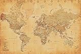
World Map (Vintage Style) Art Poster Print
17th Century World Map (Antique) Art Poster Print

world map in words

I find this map absolutely fascinating and suspect that it would be a real talking point as well as proving to be quite educational because you would read the names every time you looked at the map.
It could also inspire an art / geography assignment for older children to try to make their own word map, maybe on a computer using a graphics program with layers, putting an outline map on the first layer and then using a text tool to fill in the countries with their names on a second layer.
world map in words
Where will you use your world map poster?
World Map Wall Sticker Decals
More World Maps for Around the Home
World Placemat

Puzzle & Poster Series Map of the World

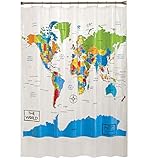
Home World Map Shower Curtain
Personalized World Map Poster
currently not available :-(

Whimsical Personalized Worlp Map
Fun to design your own map
Creating this map will be so much fun for your children. They will get to edit the text and pictures on this lovely world map. It has both real and fantasy animals (but you can remove any you wish). I played around with the editor and changed my little corner of the world. See the picture on the right - you can see my garden in Sydney.


